Catalina - Capri - 25s International Assocaition Logo(2006)  
Assn Members Area · Join
Association Forum
Association Forum
Home | Profile | Register | Active Topics | Forum Users | Search | FAQ
Username:
Password:
Save Password
Forgot your Password?

 All Forums
 Catalina/Capri 25/250 Sailor's Forums
 General Sailing Forum
 What is the best GPS for the money
 New Topic  Topic Locked
 Printer Friendly
Author Previous Topic Topic Next Topic  

djn
Master Marine Consultant

Member Avatar

USA
1561 Posts

Initially Posted - 04/17/2006 :  09:18:40  Show Profile
And where is the cheapest prices. Hi All, my budget is just shoot for this year but I still need a GPS. What do you think the best bang for the buck is? (what a horrible sentance)

Reminds me of a joke. This guy from down south with a strong drawl is walking through the Harvard university commons and goes up to two very prepy looking chaps and asks, "Where's the library at". One of the chaps says, "At Harvard university, we do not end our sentences with a prepisition". The good old boy replied, "Oh, OK. Where's the library at ass hole!". Cheers.

Dennis
No Boat
S.E. Michigan

Edited by - on

Ericson33
Admiral

Members Avatar

USA
892 Posts

Response Posted - 04/17/2006 :  10:36:41  Show Profile  Visit Ericson33's Homepage
I got the Lowrance I finder H2Oc. Its a color screen and its handheld. It did very good in direct day light (easy to see) and if you go to there site they have some free maps so you don't have to spend the extra $$. It was 269.95 at West Marine, So you can find it cheaper than this.

The same color unit from Garmin was over 500.00.

Edited by - on
Go to Top of Page

Leon Sisson
Master Marine Consultant

Members Avatar

USA
1893 Posts

Response Posted - 04/17/2006 :  10:48:13  Show Profile  Visit Leon Sisson's Homepage
Dennis,

If I were shopping for the least expensive GPS that wouldn't make me sorry I bought it, I'd compare the discount retailers for an entry level Garmin hand held. I've been using the same no frills Garmin handheld for 10 years now, (including a trip to the Bahamas) and haven't felt the need to upgrade yet. (Although I may be beginning to feel very slight symptoms of color screen and electronic nav charts envy. Maybe next decade...)

-- Leon Sisson

Edited by - on
Go to Top of Page

Steve Milby
Past Commodore

Members Avatar

USA
5908 Posts

Response Posted - 04/17/2006 :  12:03:25  Show Profile
Ditto what Leon said. I have an expensive Garmin chartplotter and the cheapest Garmin E Trex (bought on sale in a discount grocery store for $79.95), and the E Trex tells me all I really need to know. No matter which kind of GPS you have, you need a paper chart of the area or a chartbook. An inexpensive GPS and a chart are all you need to find an unfamiliar marina entrance at night. (and a bunch of AA batteries, of course). To save batteries, I only turn it on once every hour or two and take a position, and then turn it off. The E Trex tells your position in terms of latitude and longitude, and the lines of latitude and longitude are shown on the chart. The E Trex also has an arrow that points in the direction that you should steer to get to your destination. It also tells you how fast you're going, and how long it will take to get to your destination at your present speed.

Edited by - on
Go to Top of Page

dlucier
Master Marine Consultant

Members Avatar

Virgin Islands (United Kingdom)
7583 Posts

Response Posted - 04/17/2006 :  12:10:22  Show Profile
Dennis,

Like Leon, I too am a fan of handhelds and have been using the same Garmin eTrex Mariner for about 5 years now. It came with all the navigational aids preprogrammed and pretty much does everything I need it to do, such as pointing me in the right direction. As far as I can tell, it has pretty much the same data as the more expensive fixed units, but lacks the color charting capability and fancy screen presentation. It does have NMEA out, so I can interface it with my autopilot (although I've only played with this feature once or twice) and I can put it in my shirt pocket when I go camping. I even used it a couple of times at work to get a bearing and distance for a line of sight radio data link.

So if price and portability are the driving criteria, then a handheld may be your best choice.


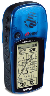
If I were buying a new handheld, I'd probably go with the Garmin eTrex Legend ($134.95 @ The GPS Store).

[url="http://www.thegpsstore.com/"]The GPS Store[/url]


Edited by - on
Go to Top of Page

Waterboy
Navigator

Members Avatar

USA
204 Posts

Response Posted - 04/17/2006 :  12:23:50  Show Profile  Visit Waterboy's Homepage
Ditto the Garmin eTrex Legend ... you can load a variety of detailed maps and charts (the same ones Garmin's chartplotters use), or just use lat/lon and your paper charts. Its hard to go wrong at this price.

Edited by - on
Go to Top of Page

Charlie Vick
Captain

Members Avatar

USA
423 Posts

Response Posted - 04/17/2006 :  12:26:18  Show Profile
Dang, I paid almost $200 for my Legend and that
was almost 4 years ago and from Wally World!
It is a great little GPS though.

Edited by - on
Go to Top of Page

dlucier
Master Marine Consultant

Members Avatar

Virgin Islands (United Kingdom)
7583 Posts

Response Posted - 04/17/2006 :  13:34:42  Show Profile
Wal-Mart online has the Garmin eTrex Legend for $132.44 plus $7.97 shipping.

[url="http://www.walmart.com/catalog/product.do?product_id=1194193"]Walmart Garmin eTrex Legend GPS Unit[/url]


Edited by - on
Go to Top of Page

djn
Master Marine Consultant

Members Avatar

USA
1561 Posts

Response Posted - 04/17/2006 :  13:57:35  Show Profile
WOW, thanks all for your input. I am suprised at how small the eTrex screen display is. For those of you that have one, can you read it well? The screen display is only 2.1H x 1.1W. Cheers.

Edited by - on
Go to Top of Page

Tom Potter
Master Marine Consultant

Members Avatar

USA
1913 Posts

Response Posted - 04/17/2006 :  14:13:31  Show Profile
Dennis, if you have a laptop you can get the cheapest handheld that has NMEA and hook the GPS to your laptop then download a free mapping program like SeaClear and your set with a cheap chartplotter.
Another note:
I know it cost more but the color screens are worth it. Color screens are very easy to see in the bright sunlight.

Edited by - on
Go to Top of Page

djn
Master Marine Consultant

Members Avatar

USA
1561 Posts

Response Posted - 04/17/2006 :  14:24:35  Show Profile
Hi Tom, I have looked into that and have the laptop to do that, but it was very combersom in a small boat. Also, my laptop is where I make my money so I don't want to put the in jepordy. I got the 160...thanks, it looks great.

Edited by - on
Go to Top of Page

Tom Potter
Master Marine Consultant

Members Avatar

USA
1913 Posts

Response Posted - 04/17/2006 :  14:35:10  Show Profile
Hope the 160 works out okay for you, it was a nice unit. If you go with the handheld GPS just make sure it has the NMEA hookup. Later on down the road you may find a cheap laptop on e-bay.

Edited by - Tom Potter on 04/17/2006 14:35:54
Go to Top of Page

Rich G
Navigator

Members Avatar

226 Posts

Response Posted - 04/17/2006 :  20:55:21  Show Profile
I got my Garmin eTrex Legend C on Amazon.com last year. I don't remember exactly what I paid for it, but I remember it was cheap, especially if you sign up for an Amazon.Com credit card and get free shipping and an extra $30 off for your troubles.

Best purchase I made last year (after the boat, of course).

Edited by - on
Go to Top of Page

OLarryR
Master Marine Consultant

Members Avatar

USA
3477 Posts

Response Posted - 04/18/2006 :  06:45:23  Show Profile  Visit OLarryR's Homepage
Coincidentally, since you asked which one is cheapest, I just got a Magellan Meridian Marine handheld with charts loaded for at least the Potomac River for free !

My friend just bought a 26' larsen motorboat and it has GPS installed in it. he gave me his 2 yr old Magellan this past weekend and said to consider it a BDay present. I see from the old receipt he had in the booklet that came with it that he bought it 2 yrs ago for $349.


I have a Humminbird Matrix 17 fishfinder. This fishfinder has GPS capability if the optional unit is bought . But it apparently can also be hooked up to other GPS units. There is a cord that I can buy that will hook up the GPS handheld to the fishfinder and then be able to use the larger screen on the fishfinder. At least that is my undestanding. I will eventually get around to buying that cord.

The handheld is okay and they are the most reasonable GPS units to buy. Also, you can conveniently have it up close to you while sailing. However, the screen is small. My thought is that each person is going to have preferences on just how large a screen is best suited for them to view satisfactorily versus ease by which it can be viewed from a distance or if close up is convenient and acceptable versus cost. many may find they do not want to hold onto it while sailing and to mount it on a stern rail, etc may be convenient for some viewing positions but maybe not. Up front at the bulkhead is convenient since you are mostly always looking forward but then you need a largeer screen and one that has good resolution and contrast. These are the things I would consider if i was buying one myself. I probably would not go with a handheld but then again....if had to pay $600+ I probably would not get it. I have my charts and the fishfinder provides me depths and river contour. As it turns out, I lucked out with a friend giving me his handheld. I have yet to use it onboard so maybe I will have to revise my comments if I find the small screen and holding/mounting is not a problem for using it.

Edited by - on
Go to Top of Page

welshoff
Captain

Members Avatar

USA
253 Posts

Response Posted - 04/18/2006 :  10:26:31  Show Profile
I use Magellan Meridian Marine (non color screen). It comes with chart disc for the computer, computer cable, lighter adapter, cradle, and SD memory card. It has NEMA outputs if desired. You can download different charts to the memory cards. You can only put one chart area on a memory card though, but you can switch out the memory cards. I am going to get a couple more memory cards for when I sail out of my usual area. You can use the computer to chart courses and download to the GPS/memory card.

It works great, it is nice to follow your movements around on a map showing depths and locations. You can see it under almost all sun angles (sometimes direct sun is a little hard).

It is a little hard on batteries, so keep plenty extra. Or plug into a 12V source. I bought a GPS mount (Edson) on ebay and mount it near the helm. The GPS unit comes with a nice cradle that mounts to the Edson GPS arm.

Edited by - on
Go to Top of Page

ClamBeach
Master Marine Consultant

Members Avatar

3072 Posts

Response Posted - 04/18/2006 :  12:16:51  Show Profile
Very pleased with my Lowrance... I think Garmin is becoming overpriced in the marketplace.

IMHO: Having chartplotter functions with (at least) a base map is worth every penny. Seeing your position displayed on a chart is a great confidence builder compared to numbers on a screen.

Remember that a prudent skipper always maintains a backup navigation plan. Awareness of depth, current and at least a thumbnail dead reckoning position are important. GPS charts are pretty accurate in the US, but elsewhere in the world the maps can be be off... by miles.

Edited by - on
Go to Top of Page

At Ease
Admiral

Members Avatar

672 Posts

Response Posted - 04/18/2006 :  17:12:48  Show Profile
Regardless of which you get, shop around on the internet before buying. I just bought a Garmin for the vehicles, msrp $1076, Best Buy $1000, The GPS Store, $1000, WalMart (online)$758, and Caplink (http://www.caplinktech.com/), $693 (no tax, free shipping).

Edited by - on
Go to Top of Page

stampeder
Master Marine Consultant

Members Avatar

1608 Posts

Response Posted - 04/18/2006 :  17:43:26  Show Profile
I have a cheap Garmin and a laptop with mapping software. I find that I mostly use the GPS to help me locate places I've identified on a paper chart...and for telling me how fast I'm going.
So, if I were shopping again, I'd really think about what I want it to do for me. I spent too much money on the mapping software and ended up not using it for anything other than figuring out how to use it. But if I ever do circumnavigate South America, I'm ready.
My GPS is for emergencies (fog), speed, water depth and to mark my favorite anchorages.
I thought having a big screen would be beneficial but it turns out that at the speed I sail, I don't go all that far.


Edited by - stampeder on 04/18/2006 18:34:16
Go to Top of Page

clayC
Navigator

Members Avatar

USA
207 Posts

Response Posted - 04/18/2006 :  17:54:19  Show Profile
I have The Garmin iQue 3600, My Department feels I needed a palm pilot. When the auditor called and asked why I needed a GPS I told him I not only needed to know when the meeting was, I needed to be able to find it! He seemed OK with that. It came with every road map in the country but not much detail of Utah Lake.

Clay

Edited by - on
Go to Top of Page

djn
Master Marine Consultant

Members Avatar

USA
1561 Posts

Response Posted - 04/18/2006 :  18:51:56  Show Profile
Here is one for the books. A friend of mine just came over and after selling his old fishing boat and buying a new one, gave me his Garmin 172C!!! He wished me luck and went home. I am still flabergasted. It has all the blue something waterways and mount and books. How cool is that. Cheers.

Edited by - on
Go to Top of Page

Lightnup
Master Marine Consultant

Members Avatar

USA
1016 Posts

Response Posted - 04/18/2006 :  19:33:51  Show Profile
With that kind of luck going for you today, you should go buy a lottery ticket.

Edited by - on
Go to Top of Page

Tom Potter
Master Marine Consultant

Members Avatar

USA
1913 Posts

Response Posted - 04/18/2006 :  20:04:47  Show Profile
You owe him some rail time

Edited by - on
Go to Top of Page

aeckhart
Master Marine Consultant

Members Avatar

USA
1709 Posts

Response Posted - 04/19/2006 :  10:06:34  Show Profile  Visit aeckhart's Homepage
I used a 10 year old hand-held Magellin until two years ago when I got lost in a very thick Lake Superior fog. I was navigating using the GPS and a chart - for depth contours, without any problems until I answered a radio call from someone nearby who has also lost in the fog. That moment of inattention, a probably a measure os inexperience, nearly put me on an island I thought was a half mile to port. I vowed then to either get radar or a chart plotter. I ended up buying a Magellin FX 324 color chart plotter. I've sailed or motored in fog and at night with it and know where I am in relation to obstructions at a glance. It's great. I don't leave my mooring without it.

Edited by - on
Go to Top of Page

gracer
1st Mate

Members Avatar

USA
39 Posts

Response Posted - 04/19/2006 :  10:29:37  Show Profile
Anyone with a hand held GPS should check out http://www.geocaching.com/. A fun treasure hunting activity while your boat is on the hard or while not sailing. Actually, we have two in my area that you need a boat to get to them.

Bob

Edited by - on
Go to Top of Page

Dave Bristle
Master Marine Consultant

Members Avatar

Djibouti
10005 Posts

Response Posted - 04/19/2006 :  16:22:04  Show Profile
Another source to check prices is www.gpsdiscount.com. They gave me a price on a 276C that they had negotiated with a corporate fleet operator--better than what they list online. I'm not saying they'll do that for just anyone...

Edited by - on
Go to Top of Page

ilnadi
Captain

Members Avatar

452 Posts

Response Posted - 04/20/2006 :  13:27:15  Show Profile
Garmin 60C. Hend-held, color, chartplotter, real antenna. Love it.

Another good source is (www.gpsinformation.net), some guys that review a lot of gear. The site is down right now, don't know if it is temporray or not.

Also John Bell has an excellent tutorial you can download (http://www.smallboatgps.com/), well worth the $5 he asks people to donate to cover costs. I printed it in book format and read it now and then.

Edited by - on
Go to Top of Page
  Previous Topic Topic Next Topic  
 New Topic  Topic Locked
 Printer Friendly
Jump To:
Association Forum © since 1999 Catalina Capri 25s International Association Go To Top Of Page
Powered By: Snitz Forums 2000 Version 3.4.06
Notice: The advice given on this site is based upon individual or quoted experience, yours may differ.
The Officers, Staff and members of this site only provide information based upon the concept that anyone utilizing this information does so at their own risk and holds harmless all contributors to this site.