Catalina - Capri - 25s International Assocaition Logo(2006)  
Assn Members Area · Join
Association Forum
Association Forum
Home | Profile | Register | Active Topics | Forum Users | Search | FAQ
Username:
Password:
Save Password
Forgot your Password?

 All Forums
 Catalina/Capri 25/250 Sailor's Forums
 General Sailing Forum
 Good GPS for boating?
 New Topic  Topic Locked
 Printer Friendly
Next Page
Author Previous Topic Topic Next Topic
Page: of 2

PCP777
Master Marine Consultant

Member Avatar

USA
1225 Posts

Initially Posted - 12/23/2009 :  07:55:15  Show Profile
Right now woot has the Bushnell ONIX 200 GPS System with TruView Navigation on sale for $60. Is this unit any good for inland sailing? What should I look for on a GPS unit for boating?

http://www.woot.com/

After further review it seems like this unit has only received very negative reviews, albeit most of those are from people who paid $200. Still, what GPS units would you guys recommend? What are the must have features? I know little to nothing about marine GPS units.


Peter Powers
1979 TR/FK #1390
~Stephanos~
Bayview Marina,
Lake Ray Hubbard
Dallas, TX


Edited by - PCP777 on 12/23/2009 08:08:07

Sloop Smitten
Master Marine Consultant

Members Avatar

USA
1181 Posts

Response Posted - 12/23/2009 :  09:16:43  Show Profile
Peter,
For sailing on a lake its probably fine. You can mark your own points of interest and it will appear on the screen. Probably good as a backup for coastal sailing but not a primary. Personally I use a Humminbird depth finder with GPS for my primary and a Garmin Handheld eTrex as my backup. The Humminbird serves as a good depth finder and also has a function you can use to alert you if you are dragging anchor. However it does not have one primary function, VMG - Velocity Made Good, which is to advise you of the progress you are making toward your target if you are bearing off to a different heading. If I purchased another it would at least have that function. I know there have been a lot of discussion about this topic in the past and a search for GPS should disclose a wealth of information.

Edited by - on
Go to Top of Page

piseas
Former Treasurer

Members Avatar

USA
2017 Posts

Response Posted - 12/23/2009 :  14:34:28  Show Profile  Visit piseas's Homepage
Peter, It really depends on your needs, where you sail, etc. and of course your budget. As already stated you can do a search in our forum. Stay with main names like Garmin and Magellan. West Marine has a pretty good sale right now as well.
You can do a little reading [url="http://www.westmarine.com/webapp/wcs/stores/servlet/westadvisor/10001/-1/10001/GPS-Receivers.htm"]HERE[/url] as well.
Good luck.
Steve A

Edited by - on
Go to Top of Page

Voyager
Master Marine Consultant

Members Avatar

USA
5381 Posts

Response Posted - 12/23/2009 :  15:58:32  Show Profile
I've got both a Garmin GPS-76 (1-2 years old) and a Magellan Explorist (5 years old) and they are both excellent for coastal cruising.

With built-in maps (Magellan) and charts (Garmin), you can plan a trip by entering a variety of waypoints and routes before you go out. If you use the computer interface, that makes it easy to enter your points and routes.

I've also used the Magellan for lake sailing and kayaking - to ID favorite fishing spots, rocks or other features.

If you have a VHF radio that provides VSC functionality, you can use the GPS's NMEA serial output to deliver real time Lat / Long to the radio if you hit the panic button. Allows the Coasties or lake patrol to find your exact location.

Good luck on whatever you choose.

Edited by - Voyager on 12/23/2009 16:00:00
Go to Top of Page

Steve Milby
Past Commodore

Members Avatar

USA
5902 Posts

Response Posted - 12/24/2009 :  08:34:09  Show Profile
Even if you sail on a small inland lake, where all navigation is by line-of-sight and you don't need a GPS to find your way from place-to-place, a GPS can still be useful. One function of GPS is that it tells you your speed, and many of us like to know that in order to see whether our sail trim changes are improving our boatspeed. For this purpose, an inexpensive GPS is much less costly than a knotmeter.

Every <u>marine</u> GPS I have seen, however inexpensive, tells you your speed, the direction to your next waypoint, the estimated time of arrival at your next waypoint, and the latitude and longitude at your present position. (I don't think the Bushnell is a marine gps.) With that basic information, you can navigate almost anywhere in the world. You can transfer the lat/long to a paper chart and that will give you a "fix" of your present position. If you wait 30 minutes or an hour, and again plot your lat/long onto your paper chart, a line drawn between those two points will constitute a line of position. Thus, even the cheapest, simplest GPS will give you more information, more easily than the finest sextant. The GPS represents a great step forward in navigation, but most long distance sailors recommend the use of a sextant as a backup to the GPS, in case the GPS fails, or the satellite system itself should fail.

The least expensive GPS' are powered by AA batteries. Those are adequate for occasional cruising, but, if you do a lot of cruising, it's nice to be able to connect the GPS to the ship's 12 volt house batteries.

The big step up in terms of cost is to a chartplotter. A chartplotter has nautical charts in its memory, and will display your present position on that chart, eliminating the need for you to plot it onto a paper chart. I'm colorblind, and it's very difficult for me to distinguish between red and green lights at night, but, a chartplotter displays my boat's present position, and shows the location of all navigational marks in the area, and it also displays all the depths and obstructions in the area, so it makes nightime navigation a snap. A chartplotter is also a boon in any other limited vision situation, such as fog or a heavy rainstorm. Even though you can't see the marks, their position, and your position, are displayed on the screen.

More expensive units also furnish other useful information, such as the times of tidal changes, the strength and direction of tidal currents, and other useful information.

Buy the unit that best meets your needs. If you cruise a lot, or sail on a big bay, lake or along a coast, an affordably priced chartplotter is a very good investment.

Edited by - on
Go to Top of Page

Arlyn Stewart
Master Marine Consultant

Members Avatar

USA
2980 Posts

Response Posted - 12/25/2009 :  06:30:55  Show Profile  Visit Arlyn Stewart's Homepage
I'm also in the need for a handheld unit as my old Garmin 45 no longer will acquire sats.

I fear however that technology has passed my needs by as all I want is a basic gps with computer interface.... preferably serial.

Edited by - on
Go to Top of Page

panhead1948
Captain

Members Avatar

345 Posts

Response Posted - 12/25/2009 :  08:26:03  Show Profile
I have a Lowrance i-way 600. Its has a 5 inch screen and can be used in my car or boat. It has coastal maps and the Great Lakes and a road atlas. It has worked very well for me.

Edited by - on
Go to Top of Page

Voyager
Master Marine Consultant

Members Avatar

USA
5381 Posts

Response Posted - 12/25/2009 :  09:47:04  Show Profile
The Garmin 76 series ( https://buy.garmin.com/shop/shop.do?cID=161 ) offers several lines with black and white, color, with maps, etc ranging from $200 to $800, depending on your needs. Are you looking for low price-simple unit ($200-300), mid-range unit ($300-500) or a high end?

IMHO, combo systems like depth, VHF & GPS combos are nice because you get all-in-one, however you have the old "TV with a built-in VCR" quandary. If the VCR breaks, you have to chuck the TV too!

Edited by - on
Go to Top of Page

delliottg
Former Mainsheet C250 Tech Editor

Members Avatar

USA
4479 Posts

Response Posted - 12/25/2009 :  11:25:20  Show Profile  Visit delliottg's Homepage
Arlyn, you might look into a Garmin 12, I have two of them as backups, both have USB power/data cables, and serial cables can be had. There's a company called Pfranc that makes & sells the cables for about $20. I found my last 12 series for $55 in a pawn shop,sitting forlorn next to the higher price models. The owner seemed glad to see it go.

Edited by - on
Go to Top of Page

Dave Bristle
Master Marine Consultant

Members Avatar

Djibouti
10005 Posts

Response Posted - 12/27/2009 :  12:16:12  Show Profile
I find the [url="http://www.gpsdiscount.com/products/index.html?p=808"]Garmin 276C[/url] (and now the very similar 478) has a lot of flexibility:

- Blue Charts and street mapping with voice/written driving directions.
- All standard marine functions--anchor alarm, VMG, course correction, tide charts, etc.
- Customizable screen--you pick the data you want to see in the car and on the boat, then switch from one mode to the other.
- 12-volt plug or its rechargeable internal battery that lasts 8+ hours.
- Fixed bracket on the boat and beanbag or stick-on mount for the car dash.
- USB cable for route planning and backup on my PC.
- High-resolution color screen--not huge, but bigger than most hand-helds. (Watch the resolution--it makes a difference for charts.)
- Buttons for controls. (I've tried the small touch-screens and am not sold on them.)
- Cable with wires for two NMEA ports for connection to a DSC VHF.
- Good support from Garmin--quick replies to e-mails.

If I had to replace the 276 right now, I'd probably get the 478. But I'm on coastal waters.


Edited by - Dave Bristle on 12/27/2009 12:18:06
Go to Top of Page

delliottg
Former Mainsheet C250 Tech Editor

Members Avatar

USA
4479 Posts

Response Posted - 12/27/2009 :  13:29:32  Show Profile  Visit delliottg's Homepage
I concur on the Garmin 276, that's what I use in my car as well as on the boat. I like that it has actual buttons as opposed to a touchscreen.

When it's cold the only way to operate a touchscreen is with bare fingers (or your nose), something I found out with my new Iphone when it was in the teens here for a couple of weeks. Literally I was trying to operate my phone with my nose because it was a hassle pulling off my gloves. With the 276, when I'm on the water, I can operate it even with ski gloves on, not so with Rita's Nuvi 880 which is touchscreen only.

Edited by - on
Go to Top of Page

Dave Bristle
Master Marine Consultant

Members Avatar

Djibouti
10005 Posts

Response Posted - 12/27/2009 :  14:14:39  Show Profile
One small downside to the Garmin 276/478 is that they only take Garmin's proprietary data cards. Newer Garmin models take standard SD cards. The 478, however, has charts for both coasts plus all US streets built in, so the cards aren't needed as they are on the 276 (along with optional street and chart data). That and the auto accessory items included with the 478 make it a better buy, for my purposes, than the 276 (based on gpsdiscount.com prices).

Edited by - on
Go to Top of Page

Arlyn Stewart
Master Marine Consultant

Members Avatar

USA
2980 Posts

Response Posted - 12/28/2009 :  05:50:26  Show Profile  Visit Arlyn Stewart's Homepage
After some looking... my options seem to be the new 72H or the 76Cx. The 72H can be had for $130 and the 76Cx for $250.

I like the idea of the 72H, a new high sensitivity receiver in a basic gps. But, I like unit to unit transfer ability and it doesn't provide it and doesn't say it can be externally powered.

The 76Cx is more than I need as I don't need charting, but it will do (I think) the transfers and use the power and data cabling from my defunct gps 45.

Edited by - on
Go to Top of Page

Dave Otey
Navigator

Members Avatar

USA
112 Posts

Response Posted - 12/28/2009 :  07:13:39  Show Profile  Visit Dave Otey's Homepage
I too enjoy the Garmin 276C. I believe they have been replaced with current production of the 476C. "C" being color display. Very versatile, good for marine as well as ground capabilities.

Edited by - on
Go to Top of Page

jbkayaker
Captain

Members Avatar

USA
299 Posts

Response Posted - 12/28/2009 :  18:04:06  Show Profile
I have had a couple of Lowrance GPS units for airplane driving. They gave me much more bang for the buck than Garmin. I still use an Airmap 500 for flying and occasionally when sailing. Databases for water use are available for less than Garmin's.

Edited by - on
Go to Top of Page

Sloop Smitten
Master Marine Consultant

Members Avatar

USA
1181 Posts

Response Posted - 12/28/2009 :  22:17:45  Show Profile
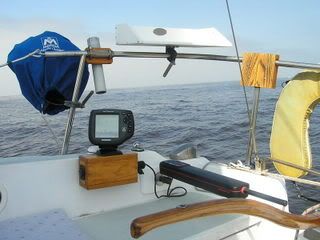
Peter,
Here is how I mounted my Humminbird. The box contains electrical connections for the depth finder/GPS, autopilot and a universal 12 volt plug (cigarette lighter style). I like the fact the unit is close enough to read small print on the display.


Edited by - on
Go to Top of Page

Unsinkable2
Captain

Members Avatar

USA
273 Posts

Response Posted - 12/29/2009 :  22:12:17  Show Profile  Visit Unsinkable2's Homepage
I use a Garmin GPSMap 76. (It floats)
I have also used the gps on my cell phone for an interesting solution one night when I ran into, uh, a bit of a problem...
http://blog.unsinkable2.com/2008/10/googles-navigation-aids-for-sailors.html

Edited by - on
Go to Top of Page

PCP777
Master Marine Consultant

Members Avatar

USA
1225 Posts

Response Posted - 01/04/2010 :  13:46:57  Show Profile
<blockquote id="quote"><font size="1" face="Verdana, Arial, Helvetica" id="quote">quote:<hr height="1" noshade id="quote"><i>Originally posted by Unsinkable2</i>
<br />I use a Garmin GPSMap 76. (It floats)
I have also used the gps on my cell phone for an interesting solution one night when I ran into, uh, a bit of a problem...
http://blog.unsinkable2.com/2008/10/googles-navigation-aids-for-sailors.html
<hr height="1" noshade id="quote"></font id="quote"></blockquote id="quote">

Interesting, I've used the Google GPS in my car and at home and typically it tells me "Your location within 1100 meters." Maybe I need to download the latest version.

Edited by - on
Go to Top of Page

Dave Bristle
Master Marine Consultant

Members Avatar

Djibouti
10005 Posts

Response Posted - 01/04/2010 :  15:01:05  Show Profile
<blockquote id="quote"><font size="1" face="Verdana, Arial, Helvetica" id="quote">quote:<hr height="1" noshade id="quote"><i>Originally posted by PCP777</i>
<br />Interesting, I've used the Google GPS in my car and at home and typically it tells me "Your location within 1100 meters." Maybe I need to download the latest version.<hr height="1" noshade id="quote"></font id="quote"></blockquote id="quote">I'm guessing your phone doesn't have GPS built in, in which case cell towers are used to triangulate your position--generally very approximate compared to GPS. Or, if you have GPS, it's acquiring only a very few satellites.

Edited by - Dave Bristle on 01/04/2010 15:02:30
Go to Top of Page

PCP777
Master Marine Consultant

Members Avatar

USA
1225 Posts

Response Posted - 01/04/2010 :  15:53:12  Show Profile
<blockquote id="quote"><font size="1" face="Verdana, Arial, Helvetica" id="quote">quote:<hr height="1" noshade id="quote"><i>Originally posted by Dave Bristle</i>
<br /><blockquote id="quote"><font size="1" face="Verdana, Arial, Helvetica" id="quote">quote:<hr height="1" noshade id="quote"><i>Originally posted by PCP777</i>
<br />Interesting, I've used the Google GPS in my car and at home and typically it tells me "Your location within 1100 meters." Maybe I need to download the latest version.<hr height="1" noshade id="quote"></font id="quote"></blockquote id="quote">I'm guessing your phone doesn't have GPS built in, in which case cell towers are used to triangulate your position--generally very approximate compared to GPS. Or, if you have GPS, it's acquiring only a very few satellites.
<hr height="1" noshade id="quote"></font id="quote"></blockquote id="quote">

It's an 8100, it shows where I am but not very well.

Edited by - on
Go to Top of Page

Dave Bristle
Master Marine Consultant

Members Avatar

Djibouti
10005 Posts

Response Posted - 01/04/2010 :  16:11:52  Show Profile
<blockquote id="quote"><font size="1" face="Verdana, Arial, Helvetica" id="quote">quote:<hr height="1" noshade id="quote"><i>Originally posted by PCP777</i>
<br />[quote]<i>Originally posted by Dave Bristle</i>
<br />It's an 8100, it shows where I am but not very well.<hr height="1" noshade id="quote"></font id="quote"></blockquote id="quote">Yup--no GPS. It uses the cell towers.

Edited by - on
Go to Top of Page

JohnP
Master Marine Consultant

Members Avatar

1520 Posts

Response Posted - 01/05/2010 :  21:11:23  Show Profile
I have tested the precision of my GPSMap76 in the Magothy River where there are lots of green and red cans marking shoals and with 10 or 11 satellites received it's good to about 5-10 feet. Nice to know. And when the water gets too skinny there, the mud banks and sand bars are very forgiving.


Edited by - on
Go to Top of Page

redviking
Master Marine Consultant

Members Avatar

USA
1771 Posts

Response Posted - 01/06/2010 :  06:17:51  Show Profile
<blockquote id="quote"><font size="1" face="Verdana, Arial, Helvetica" id="quote">quote:<hr height="1" noshade id="quote"><i>Originally posted by Voyager</i>
<br />

With built-in maps <b>(Magellan)</b> and charts (Garmin), you can plan a trip by entering a variety of waypoints and routes before you go out. I've also used the <b>Magellan</b> for lake sailing and kayaking - to ID favorite fishing spots, rocks or other features.<hr height="1" noshade id="quote"></font id="quote"></blockquote id="quote">

Stay away from Magellan. We needed a plotter on our C25 and when my wife and I got married 5 years ago, we registered at West Marine - of course! Anyway, someone bought us the Magellan FX324 color screen small plotter. Then just 6 months later, Magellan discontinued their marine line and left everyone who owned a FX324 plotter without the ability to order regional chart coverage. SO, while it will give me a rough coastal view and coordinates - it is useless for us unless we are somewhere in the Chesapeake up to Maine. We use it as a backup for our other three Garmins... Magellan just wants to make car toys not real navigation systems for boats.

Another benefit to even the handheld Garmin units is that once you know how to run that system, you can basically navigate my Garmin 3010 or whatever with its radar overlays, AIS overlay once I get it installed, and weather if I ever get around to that... My point is - if you ever charter, chances are you'll be using a Garmin.

sten

Edited by - redviking on 01/06/2010 06:29:14
Go to Top of Page

farrison
Navigator

Members Avatar

USA
166 Posts

Response Posted - 01/06/2010 :  09:41:03  Show Profile
I bought a Garmin GPS76CSx and I really like it. It floats (haven't tried it), has color screen, micro SD chip inside, uses standard AA batteries, comes with Mapsource software and USB cable. I have found topo maps on the internet for several states. I downloaded them into my desktop and then dumped them into the GPS. You can creat waypoints in the computer on the Mapsource software and dump them into it also. You can download your tracks from a day of sailing into the computer and save them on the desktop. Really cool. I even took it down the Grand Canyon on a river trip and found all the rapids, campgrounds and points of interest on the internet before the trip and dumped them into it also. My fellow river runners thought I was nuts until the end of a long day when they wanted to know how far it was to camp. Then I wasn't so crazy.

Paul

Edited by - on
Go to Top of Page

PCP777
Master Marine Consultant

Members Avatar

USA
1225 Posts

Response Posted - 01/06/2010 :  15:15:00  Show Profile
<blockquote id="quote"><font size="1" face="Verdana, Arial, Helvetica" id="quote">quote:<hr height="1" noshade id="quote"><i>Originally posted by farrison</i>
<br />I bought a Garmin GPS76CSx and I really like it. It floats (haven't tried it), has color screen, micro SD chip inside, uses standard AA batteries, comes with Mapsource software and USB cable. I have found topo maps on the internet for several states. I downloaded them into my desktop and then dumped them into the GPS. You can creat waypoints in the computer on the Mapsource software and dump them into it also. You can download your tracks from a day of sailing into the computer and save them on the desktop. Really cool. I even took it down the Grand Canyon on a river trip and found all the rapids, campgrounds and points of interest on the internet before the trip and dumped them into it also. My fellow river runners thought I was nuts until the end of a long day when they wanted to know how far it was to camp. Then I wasn't so crazy.

Paul
<hr height="1" noshade id="quote"></font id="quote"></blockquote id="quote">

That looks like a really nice unit.

Edited by - on
Go to Top of Page

delliottg
Former Mainsheet C250 Tech Editor

Members Avatar

USA
4479 Posts

Response Posted - 01/06/2010 :  18:11:08  Show Profile  Visit delliottg's Homepage
<blockquote id="quote"><font size="1" face="Verdana, Arial, Helvetica" id="quote">quote:<hr height="1" noshade id="quote">Then I wasn't so crazy<hr height="1" noshade id="quote"></font id="quote"></blockquote id="quote">

Funny how the geek in us becomes useful simply because we were interested enough in new technology to learn how to use it.

Edited by - on
Go to Top of Page
Page: of 2 Previous Topic Topic Next Topic  
Next Page
 New Topic  Topic Locked
 Printer Friendly
Jump To:
Association Forum © since 1999 Catalina Capri 25s International Association Go To Top Of Page
Powered By: Snitz Forums 2000 Version 3.4.06
Notice: The advice given on this site is based upon individual or quoted experience, yours may differ.
The Officers, Staff and members of this site only provide information based upon the concept that anyone utilizing this information does so at their own risk and holds harmless all contributors to this site.