Catalina - Capri - 25s International Assocaition Logo(2006)  
Assn Members Area · Join
Association Forum
Association Forum
Home | Profile | Register | Active Topics | Forum Users | Search | FAQ
Username:
Password:
Save Password
Forgot your Password?

 All Forums
 Catalina/Capri 25/250 Sailor's Forums
 General Sailing Forum
 Integrated Wireless AIS/Chartplotter system
 New Topic  Topic Locked
 Printer Friendly
Author Previous Topic Topic Next Topic  

TakeFive
Master Marine Consultant

Member Avatar

2272 Posts

Initially Posted - 02/21/2011 :  07:08:54  Show Profile
Over the weekend I finished installing my newly arrived Standard Horizon GX2150 VHF/DSC/AIS radio. Because of the large amount of commercial traffic where I sail, I was very interested in getting the AIS output integrated on a chartplotter display. I had originally purchased a Garmin 640 for this, but decided I could actually do better for much less cost with a PC-based system. My MSI Wind netbook has an extremely bright display that is viewable in full daylight, so I bought a RAM Mount to put it on my pedestal guard. OpenCPN's features and stability have improved greatly in the past several months, and it uses NOAA raster and vector charts which can be downloaded for free. OpenCPN also supports AIS input and autopilot output. I wanted complete freedom to put the netbook in the cockpit or move it into the cabin, so I made everything transmit wirelessly to/from the netbook via Bluetooth.

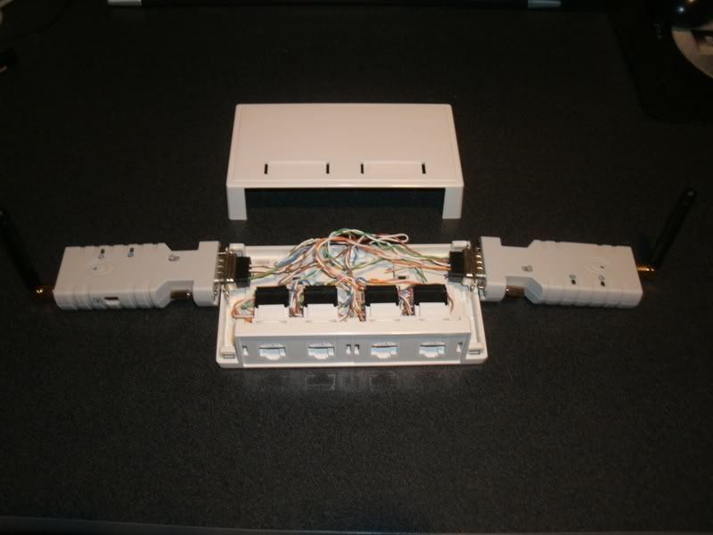
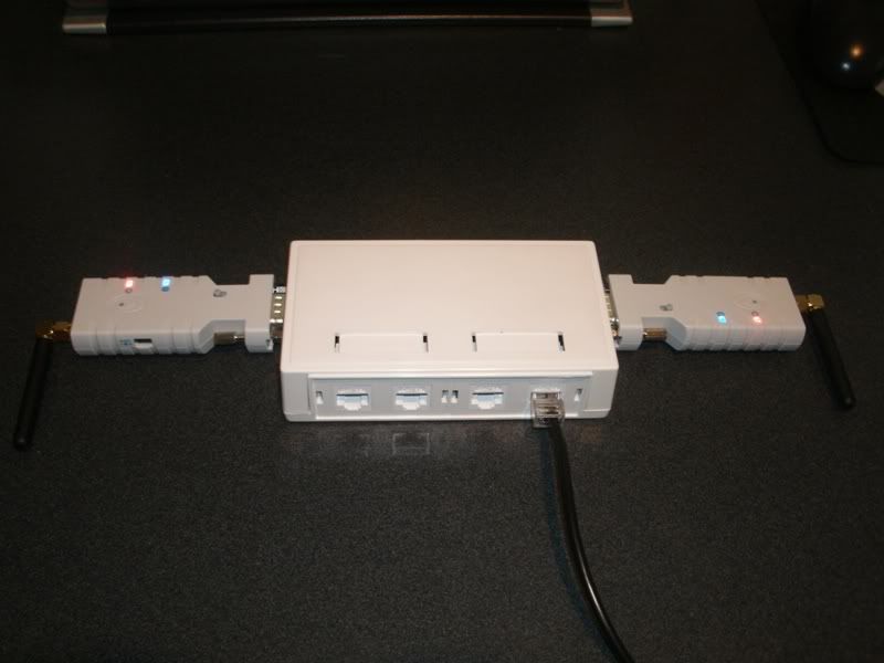
In order to make for a tidy installation (and to allow me to wire everything up in the comfort of my home), I picked up a small surface-mount network box to serve as the central interface module for the system. I daisy-chained some RJ45 receptacles to make an 8-wire bus, and terminated all the instrument wires with crimp-on RJ45 connectors. I also mounted a couple of DB9 ports in the box to attach the Bluetooth transmitters without any cumbersome cables. The whole thing runs off a 5v supply from a USB power adapter, and draws under 270 mA @ 5v. Here's the schematic and wiring plan:

<center></center>

The admiral thought the flashing lights on the interface module were "real purty". It kind of reminds me of a miniature model of the International Space Station :

<center>

</center>

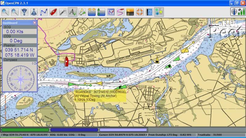
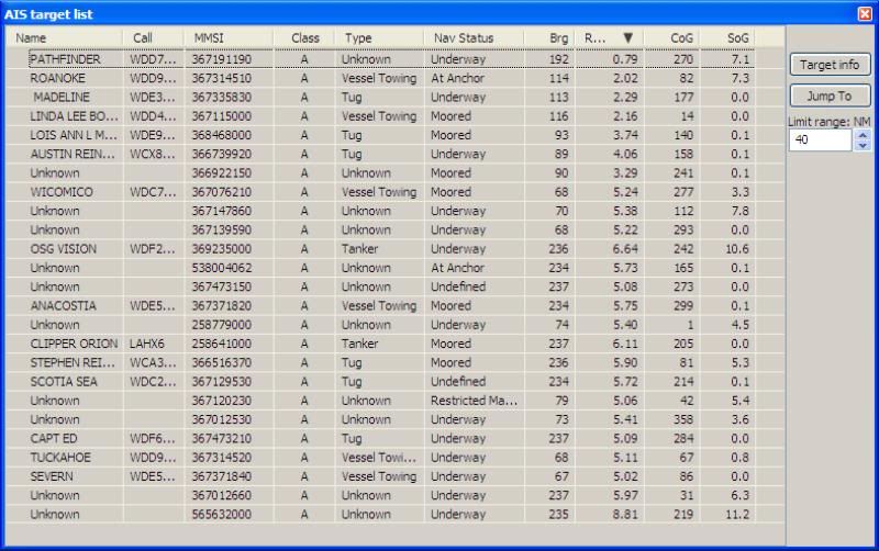
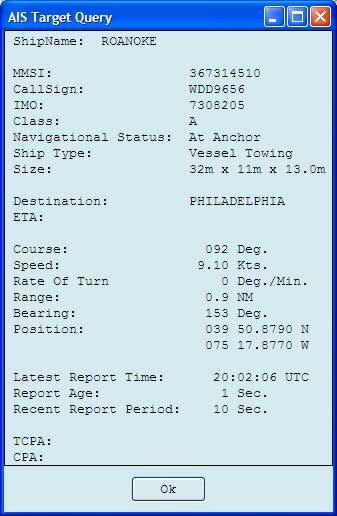
After crimping the RJ45 plugs onto the various components, I took it all down to the boat, hooked it up and fired up OpenCPN on the Netbook. After configuring all the COM ports it worked perfectly, receiving all the data wirelessly through Bluetooth. Here are some screen shots showing my boat on the hard at West End Boat Club. With a temporary antenna (since my mast is down) I was able to pick up over 20 AIS targets in my vicinity, pull up preliminary info by mouse-over and detailed info by right-clicking on a target. Many of the boats were anchored. Those that were moving showed a vector that represented their estimated location in 5 minutes (user adjustable). The yellow boat(s) are ones the meet some user-adjustable criterion for collision threat. (Still need to get familiar with the particulars.) When my boat is underway it will estimate distance and time of closest point of approach:

<center>


</center>

In addition to achieving a new height in geek factor, this will be a very useful safety feature in staying out of the way of shipping traffic in our busy river.

Rick S., Swarthmore, PA
PO of Take Five, 1998 Catalina 250WK #348 (relocated to Baltimore's Inner Harbor)
New owner of 2001 Catalina 34MkII #1535 Breakin' Away (at Rock Hall Landing Marina)

Edited by - on

Dave5041
Former Mainsheet Editor

Members Avatar

USA
3758 Posts

Response Posted - 02/21/2011 :  09:33:26  Show Profile
Impressive integration. I keep my 15" Macbook Pro below with MacEnc running using my bluetooth gps puck and can easily see my position from the tiller, but but integrating wind and other data from my Raymarine bi-data system would be pretty cool. I would never approach your geek stardom, but auto saving that data in tracks would be nice.

Edited by - on
Go to Top of Page

TakeFive
Master Marine Consultant

Members Avatar

2272 Posts

Response Posted - 02/21/2011 :  11:20:09  Show Profile
<blockquote id="quote"><font size="1" face="Verdana, Arial, Helvetica" id="quote">quote:<hr height="1" noshade id="quote"><i>Originally posted by Dave5041</i>
<br />...auto saving that data in tracks would be nice.
<hr height="1" noshade id="quote"></font id="quote"></blockquote id="quote">
OpenCPN does have automatic tracking capability, and I think that if you right-click on the track it will export to a file. But I haven't experimented much with that feature because I also have an Oregon 400c GPS that automatically captures tracks. Last season I exported the Oregon tracks into my computer every couple of weeks, so I have every track that I sailed last year. (Kind of anal, I guess.) This year I will continue to use the Oregon as my primary device at the helm - the netbook will only be turned on as needed to get a look at what traffic is looming on the horizon (we're always wondering if the distant tankers are anchored or coming toward us) and then left on if there is any imminent threat in the area.

In my original designs (Plans A-E lol ) I was going to use the Oregon tethered to the netbook as my GPS, and send the GPS data to the AIS/DSC receiver via Bluetooth, but that would have required having the netbook on all the time, so I added the hard-wired 18x GPS puck because AIS and DSC were important enough to have a dedicated GPS all the time, even when the netbook is turned off (or its battery goes dead).

Edited by - on
Go to Top of Page

Voyager
Master Marine Consultant

Members Avatar

USA
5413 Posts

Response Posted - 02/21/2011 :  13:00:31  Show Profile
Rick
This is a very beautiful thing.

Is the AIS receive-only on your VHF? If so, you are not transmitting your position, only receiving the positions of those pesky barges, tankers and floating battering rams! Nice to know what's coming your way.

I like the use of RJ45 connections for cabling the components - the wire is cheap and easily replaceable.

Did you weatherproof the box - rubber gaskets on connections and the cover? As well, perhaps applying some dielectric grease (after plugging in modules and cables) would help protect the receptacles and prevent corrosion.

Edited by - on
Go to Top of Page

TakeFive
Master Marine Consultant

Members Avatar

2272 Posts

Response Posted - 02/21/2011 :  13:24:35  Show Profile
The AIS is receive only, and built into the GX2100 or 2150. Transponders are a lot more expensive. The tankers aren't gonna get out of my way anyway, so 95% of the value is in receiving. My old radio did not have DSC, so it's all new to me. But I think that if the need ever arises, I can manually send out my position to a vessel via DSC. So that's a lot like AIS, except I have to do it manually instead of it being sent out automatically every 2-10 seconds. Some have raised privacy concerns about doing that anyway (see the latest Practical Sailor issue).

Your waterproofing idea is a good one, but I am going to leave things in a semi-temporary state for awhile to make sure I don't want to reconfigure anything. All the contacts are gold plated, so much of the corrosion would be minimized. And my boat is very dry, with dehumidifier (in season) and DampRid (on the hard).

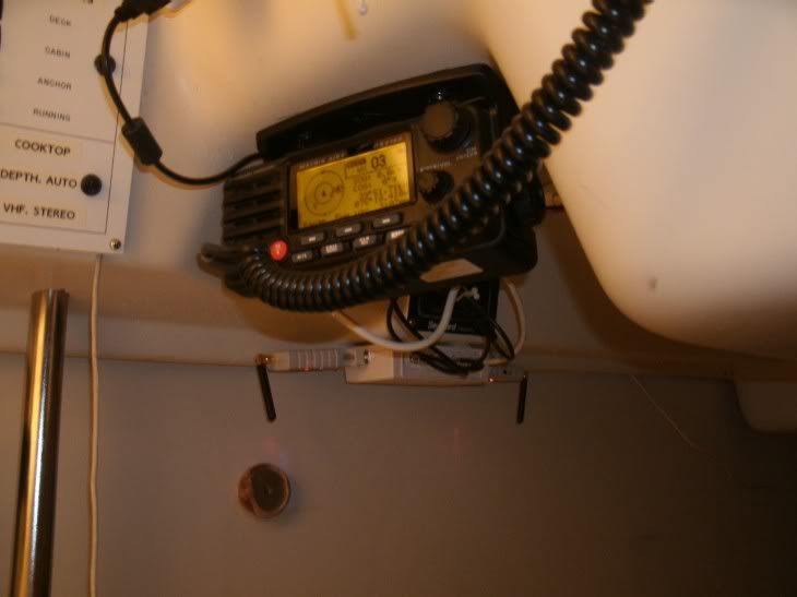
[EDIT: Maybe I didn't make it clear enough - the box is INSIDE the cabin, on the ceiling behind the radio and under the LPG switch. So weatherproofing might be overkill anyway. I'll post a picture next time I get to the boat with camera.]

Edited by - TakeFive on 02/21/2011 13:31:49
Go to Top of Page

Harleyworker
1st Mate

Members Avatar

USA
73 Posts

Response Posted - 02/22/2011 :  12:00:45  Show Profile
You say your wondering if that distant tanker is anchored or coming towards you, but in the example you posted the "Roanoke" is at anchor but moving at 9.1 knots!? How do you tell? Other than seeing if it really did move with the next update of the AIS?
Love the wireless setup, wish I had that much electronic geekness in me.

Edited by - on
Go to Top of Page

TakeFive
Master Marine Consultant

Members Avatar

2272 Posts

Response Posted - 02/22/2011 :  12:36:37  Show Profile
In monitoring the AIS website (marinetraffic.com), I've noticed that these sorts of conflicts can be common. Although I do not know much about how the system works, I believe that &gt;300 ton vessels with class A transponders have to manually update some of their information, such as destination (since that's the only way I can figure the destination information gets posted). I've seen several cases where their destination is listed as Philly but they are traveling away from Philly, so it looks like they may sometimes forget to update that information when they turn around. Maybe the Underway/Moored/Anchored information has to be updated manually also, and is therefore susceptible to error.

However, I am virtually positive that SOG and COG come directly from their GPS, not from a manually updated manifest, so in the conflict that you pointed out I would always believe the SOG and COG over anything else. If SOG is 0, I would presume it to be moored, anchored, or slowly drifting. And if SOG is 10, I'm getting out of the way whether it says "Anchored" or not. The class A transponders update every 2-10 seconds, so you don't need to wait long to see their icons move on the screen. And you really don't need to wait at all - the length of the vector shows their speed and direction at a glance without the need to mouse over.

I'll learn more as I gain more experience with this and compare the results to my actual observations. Also, it's important to note that pleasure vessels will typically have class B transponder (if they choose to transmit at all) and class B provides much less information than class A.

Edited by - TakeFive on 02/22/2011 12:38:01
Go to Top of Page

JohnP
Master Marine Consultant

Members Avatar

1520 Posts

Response Posted - 02/22/2011 :  13:33:38  Show Profile
It really does make sense to have a good system to keep track of the ships in your sailing area.

Have you ever motored through the Chesapeake and Delaware Canal?

Edited by - on
Go to Top of Page

jhinton
Navigator

Members Avatar

USA
123 Posts

Response Posted - 02/22/2011 :  13:37:16  Show Profile
You're correct. That information (anchored, underway, moored, destination, ETA, etc...) is all input by the user and is often forgotten. Speeds and courses are all automatically updated via GPS. AIS is a great tool but is only as good as the users make it.

Edited by - on
Go to Top of Page

TakeFive
Master Marine Consultant

Members Avatar

2272 Posts

Response Posted - 02/22/2011 :  14:27:25  Show Profile
<blockquote id="quote"><font size="1" face="Verdana, Arial, Helvetica" id="quote">quote:<hr height="1" noshade id="quote"><i>Originally posted by JohnP</i>
<br />...Have you ever motored through the Chesapeake and Delaware Canal?
<hr height="1" noshade id="quote"></font id="quote"></blockquote id="quote">
We motored C&D round-trip last September. The big boys stir up quite a wake, and the waves reflect off the sides and don't dissipate much. One guy had us pitching for about 1/2 hour after he passed us - the wake just kept on bouncing off the sides. For the return trip we left Engineer's Cove at 4 am and we were very nervous about pulling out in the darkness. AIS would have been really beneficial for that.

I'm really looking forward to having AIS this year. Typically there are 3 or 4 tankers anchored within our view, often waiting for high tide to start the run downriver. Once they start, you've got about 5 minutes to get out of the way if they're 1 mile downrange. This will be an excellent early warning system. We never had a close call last year, but we were always nervous because we didn't know when they would start moving.

Edited by - on
Go to Top of Page

TakeFive
Master Marine Consultant

Members Avatar

2272 Posts

Response Posted - 02/22/2011 :  19:11:55  Show Profile
I got a picture of the installation today. Those who are familiar with the C250 will recognize the location. I still need to clean up the excess wiring. I might actually move the communication module up into the cavity above the ceiling liner, completely out of sight. But I want to test it a little more first:

<center></center>

Edited by - on
Go to Top of Page

PZell
Admiral

Members Avatar

USA
548 Posts

Response Posted - 03/01/2011 :  11:36:26  Show Profile
Rick, Did you get my email through site? I would like to correspond with you regarding your set-up. Maybe put it in an article for Mainsheet or in C250 tech section. My email address is heiden zell at sbcglobal.net (all one string).

Edited by - on
Go to Top of Page

TakeFive
Master Marine Consultant

Members Avatar

2272 Posts

Response Posted - 03/02/2011 :  21:26:24  Show Profile
Paul - I did <u>not</u> get your email, so I sent an email to the address that you showed. Please email me back if you received it, and let me know here if you did not. I'm not sure I got you address right - I wasn't sure know how to deal with the space between "heiden" and "zell".

Edited by - on
Go to Top of Page

TakeFive
Master Marine Consultant

Members Avatar

2272 Posts

Response Posted - 06/22/2011 :  16:38:40  Show Profile
Hey guys, I wanted to give a quick update since I've actually gotten to use this system several times now. After getting over the initial case of information overload, this system has proven extremely valuable. Every time I go out on our busy river, there has been at least one time where the AIS has given me advance warning of an approaching freighter long before I could have made visual identification. It is everything I hoped and more. The chartplotter software I'm using gives projection vectors for where the boat will be in 5 minutes (user adjustable) and calculates CPA and TCPA. On numerous occasions the data has told me I had plenty of time to cross the channel because the boat that's 2 nm away was moving slowly (or, more often than not, anchored), and on other occasions it told me not to try it.

Basically it's done everything described in [url="http://www.catalina-capri-25s.org/forum/topic.asp?TOPIC_ID=19538"]this thread from a couple years ago[/url].

Keep an eye on the upcoming Mainsheet. I submitted a general overview of AIS for the Feature section, as well as some details of my installation for the C25/250 Technical Pull-out. To make it friendly to the casual reader, I edited heavily, so it only begins to tell the whole story.

Edited by - on
Go to Top of Page

glivs
Admiral

Members Avatar

USA
836 Posts

Response Posted - 06/22/2011 :  19:08:54  Show Profile
Rick - Great job; looking forward to your articles!

Reading back through this thread about information available and what's entered automatically or manually got me thinking about local AIS use. Last summer I had the privilege to tour the control room for one of the U.S. locks on the St. Lawrence. It would rival NASA's flight control room. A large bank of wall monitors tracks every ship from the Gulf of the St. Lawrence through Lake Ontario. Banks of desk monitors support many, many other tasks, e.g. communications, data acquisition/management (AIS and other), etc. A simple mouse click on an AIS target allows access to information on whether or not a pilot is on board, draft and manifest, ballast information, position of tiller, screw rpms, ..., as well as position, heading, etc. At least within the seaway, manually entered but critical information is verified frequently as ETA's to designated locations must be manually transmitted and confirmed by radio to allow managers (both U.S. and Canadian) to monitor and schedule traffic, schedule inspections, coordinate handling of hazardous cargo, manage water levels, etc. Not a lot of wiggle room outside the channel and I was quite surprised by how often the big guys run into difficulty. AIS is just one component of the management system but it is pretty impressive.

Edited by - on
Go to Top of Page
  Previous Topic Topic Next Topic  
 New Topic  Topic Locked
 Printer Friendly
Jump To:
Association Forum © since 1999 Catalina Capri 25s International Association Go To Top Of Page
Powered By: Snitz Forums 2000 Version 3.4.06
Notice: The advice given on this site is based upon individual or quoted experience, yours may differ.
The Officers, Staff and members of this site only provide information based upon the concept that anyone utilizing this information does so at their own risk and holds harmless all contributors to this site.