Notice:
The advice given on this site is based upon individual or quoted experience, yours may differ.
The Officers, Staff and members of this site only provide information based upon the concept that anyone utilizing this information does so at their own risk and holds harmless all contributors to this site.
We have a netbook that is still running MS XP and cannot accept a newer OS, it's getting OLD!
The primary use of our Netbook is to run Garmin Homeport and review/plan/analyse our GPS data.
It's time to replace it, so now we have the choice of a new Netbook, Notebook or Tablet.
I have a Galaxy 10.1 Tablet which is great, but it cannot run programs like Homeport.
So my question: Is anyone running Homeport on any kind of tablet (yes, even a Mac/iPad)
I purchased the Netbook years ago as a gift for my wife, she has really used it well and routinely plugs the chips from our Garmin 546 into it or Attaches the Handheld via USB into it.
The replacement has to accept SD cards and ideally would have a USB port.
I am still running a netbook in the cockpit. I prefer it to everything else because its display is bright enough to see in daylight. When it dies, I do not know what I will do.
AFAIK, Homeport is not available on any tablet OS's. However, Garmin does have Bluechart software for the iPad. You might consider the Microsoft Surface. I heard that an upcoming version would run full PC version of Windows8, hence should run Homeport. I don't know when that version is coming out, though (it might even be out now for all I know).
we've tried running Garmin Bluechart on Rita's iPad, but even with the screen cranked all the way up we had a hard time viewing it unless the screen was in shadows. Of course with it cranked all the way up, battery life is severely cramped.
As far as running Homeport, it doesn't look like you can run it on Android. Do you have an iPad you could try running Bluechart on? The cost is nominal compared to any chartplotter out there, there's full Active Captain integration (which I like).
We do not use homeport for live navigation, just to prep routes, waypoints etc. and to review tracks.
So the replacement screen visibility is not an issue.
We have Active Captain hooked in, but again, we only use it for preparation and for review. We carry a Garmin 546 at the helm on a Ram mount and Garmin 76cx handheld as needed.
Paul, consider a Dell Latitude 10... it's a tablet, uses standard SD cards, runs regular windows 8, is touch screen, and will run about 4-6 hours full on... It'll run office, or any other windoze apps. It's actually just a windows computer without a keyboard, smaller, but higher resolution than the regular ipad2.
I have both of these devices, but haven't attempted to mate them up... my bluetooth GPS is probably 12 years old now (used to use, get this, MS Streets and Trips with windows 98SE mated to my laptop to use it)... finding drivers for it might be painful!
Yep, folks there ARE tablets out there that run an OS other than Android or iOS. John Schramm - whose company was using Pentium III tablets running windows XP 10 years ago for his company fork trucks from Viewsonic VT100. Proof once again, that Apple doesn't invent anything, they just market it better...
Yeah, I'd love to lug that thing around. Trade an IPad or subsequent Android for it in a second. Once you use almost any Apple product for awhile, even if you like Windows or Android better, you understand that there is a lot more to it than marketing. The Surface Pro 2 with the not included keyboard costs the same as a MacBook Air. MacEnc, unfortunately, doesn't run on IOS, but INavX, limited to raster charts, will act as a repeater for MacEnc.
that's a 10 year old tablet! there WERE NO APPLE PRODUCTS THEN! AS for the Dell, it's a dell, not exactly sleek (nothing they do is). You can get a macbook air for $499? Where?
Probably next to the store that has the Surface Pro 2 for 499. The Surface RT is the price they advertise, it doesn't run X86 programs, and the keyboard doesn't come with either of them. They are discounting the original RT, but but there isn't a lot to recommend it. It's hard to tell at this point whether the Surface line will evolve into something viable. The RT 2 and Pro 2 are supposed to be available in October. The Pro 2 uses the same processor as the base MacBook Air, so it should be much more responsive than the original and actually have usable battery life
Edit: my dual processor PowerMac is more than 10 years old and is still functional.
Every offseason I take a quick look at the different options for planning cruises and real-time navigation on the boat. I've even spent some money on HomePort and the Garmin charts to go with their Bluecharts iPad app, and a real nice little Marine Navigator Android app. But for my primary planning I keep coming back to OpenCPN, which just gets better and better. I use it at home with my big screen monitor for planning and analysis, and I load the routes into my Garmin handheld and into my netbook for use with OpenCPN in my cockpit (where I display location, AIS targets, and control my AutoPilot in track mode wirelessly via Bluetooth).
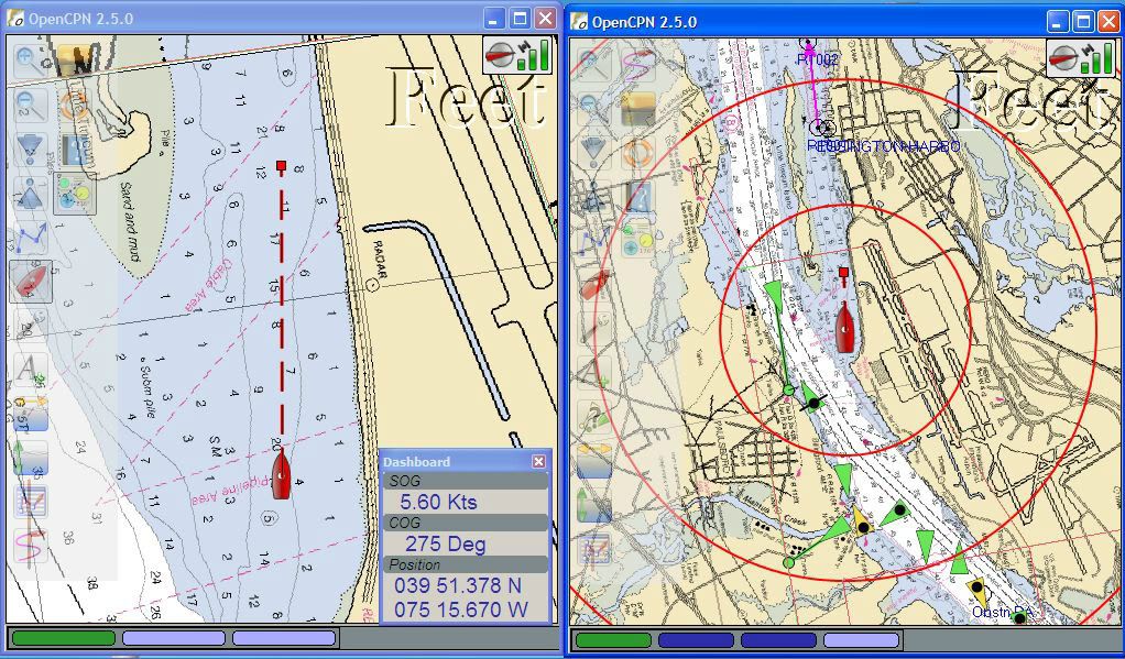
Why do I like OpenCPN so much? First, because I can update all my NOAA charts for free by simply downloading them and putting them in the chart directory. No upgrade fees, and no internet connection needed on the boat since the charts are cached. Second, because I can run two instances in side-by-side windows at different zoom levels (zoom in for local features, zoom out to see distant AIS targets) so I don't need to manipulate the display unless I want to pull up detailed information on the AIS targets.
For me, if it does not run OpenCPN, I'm not interested. Which is the main reason I stick with Windows, since the Mac version is reportedly more buggy, and Linux Bluetooth support is even worse than Windows.
This pic is out of date, because I'm using a newer verison, but you get the idea of how the dual window works:
I have also heard that the Mac version leaves something to be desired. MacEnc is the hands down winner on the Mac platform: free NOAA charts, buy Navionics Gold and Hotspots, Canadian Hydrographics, BBB, raster charts, interfaces with just about any on board electronic, overlays AIS and GRIB. P/S still ranks it with the pro level Windows programs, edit: I would still like to have vector charts in INavX on my phone and IPad - just wishing
I have PC's from 1995 that still run, that doesn't make them still useful, your antique mac isn't either. I have computers, dells in fact, that are in use today, that are 8+ years old that are used in a manufacturing environment, and they run more reliably than anything you've likely seen used, running 24x7.
I didn't recommend surface.. In fact I hate windows 8, honestly... but then.. every product line has a stinker, I mean iOS 7 really? So lets get back to facts, and stop the PC/Mac debate, because frankly it's pointless, I was trying to answer a question.
I recommended Windows 8 pro! the Latitude 10 isn't a surface or RT device. It DOES run x86 programs!
Facts not feelings please. The man asked for a PC that could run his existing programs, with a USB port, that is current hardware... I'm the ONLY ONE WHO PROPOSED A DEVICE TO FIT THE CRITERIA.
Sorry, I was just being light hearted. You use what fits. I just wanted things to be clear on the Surface.. Several companies make alternative devices, tablets and convertibles, that run Win. that seem to be better values. Microsoft was both late and weak in the tablet market, and my Win friends universally hate the schizophrenic W8.
<blockquote id="quote"><font size="1" face="Verdana, Arial, Helvetica" id="quote">quote:<hr height="1" noshade id="quote"><i>Originally posted by britinusa</i> <br />Rick, are you saying that you can create waypoints etc in OpenCPN and then load them on a chip and import them into a Garmin? <hr height="1" noshade id="quote"></font id="quote"></blockquote id="quote"> Yes, I do this all the time, but not with a chip. I export the waypoints and routes from OpenCPN to .gpx files, import into HomePort, plug the handheld into USB, and send them from HomePort into the device. No chip is involved, and if you have a chartplotter that lacks USB and requires a chip, I do not know how that would work because I have no experience with that.
Recent versions of OpenCPN have added communications settings that are supposed to allow it to send waypoints and routes direct to the Garmin device, but I have not expended much effort to get it to work.
Paul, I've used OpenCPN a couple of years now and like Rick find it very useful to plan and explore alternative routes (e.g. for N vs. S winds). I export my OpenCPN files to my Garmin handheld or import my track files to OpenCPN using Windows Explorer editing the track file, if necessary, using DNRGPS (http://www.dnr.state.mn.us/mis/gis/DNRGPS/DNRGPS.html). The hardware limitation for me is my eyes...i.e. the screen size of my handheld. Time to shop for a chartplotter.
I haven't read all the messages in this thread, but here is my limited experience... Racing, not cruising.
We have an Asus TF700T and an Asus TF300T. The tablets are small and functional, but limited. Despite having an internal GPS in both tabs, neither of them maintains a signal well enough for land navigation, and we sometimes loose the GPS for upwardso f40 - 60 minutes. I have had it drop the signal leaving our driveway, crossed Toronto, and regained signal on the way home. Not acceptable for a nav tool, at least not for my purposes.
I tried installing some race software, but found that on the boat, there is more distraction working the table than there is with either the handheld GPS or the chartplotter.
I got a BobJGear protective cover for the TF700T. It is a rubber frame that saves the tablet if it is dropped. So far the tablet has survived drops from countertop height and not had issues. I also got a clear, touchscreen enabled drybag, but it is such a hassle I have never actually used it.
Daylight visibility is very good. The tablet comes with indoor and outdoor brightness settings and in most conditions, the screen is viewable as long as it is clean.
Battery life with daylight visibility and the GPS and Wifi running is limited to about 3 hours. You can buy a 12V adapter to allow you to run the tablet from the boat battery.
We will tether the tablet to a wifi signal from SWMBO's phone if I want weather or other info while out on the boat. That can be handy.
Mostly I use the tablet to play music on the boat though :S - maybe I just haven't found the right apps yet.
<blockquote id="quote"><font size="1" face="Verdana, Arial, Helvetica" id="quote">quote:<hr height="1" noshade id="quote"><i>Originally posted by pastmember</i> <br />I CAN"T STAND IT
I know it does not matter to anyone but this thread is as close as I can get to an excuse to tell SOMEONE I have a new iMac on the way.... <hr height="1" noshade id="quote"></font id="quote"></blockquote id="quote">...with surround sound and a subwoofer? Find a good simulator and you can sail all year round!
<blockquote id="quote"><font size="1" face="Verdana, Arial, Helvetica" id="quote">quote:<hr height="1" noshade id="quote"><i>Originally posted by pastmember</i> <br />I CAN"T STAND IT
I know it does not matter to anyone but this thread is as close as I can get to an excuse to tell SOMEONE I have a new iMac on the way.
27-inch iMac Configuration NVIDIAGeForceGTX780M 4GB GDDR5 3.5GHz Quad-core Intel Core i7 8GB 1600MHz DDR3 SDRAM-2X4GB (32 gig upgrade kit in my drawer waiting) 1TB Fusion Drive (1TB USB 3.0 external waiting for back ups)
If you have not seen a current design 27" iMac it is gorgeous. I am replacing my '07 iMac... I waited long enough!
Thanks for indulging me, it might be here by Friday!!!! <hr height="1" noshade id="quote"></font id="quote"></blockquote id="quote">
Out of curiosity, why choose an iMac over a Mini? I have a 2007 Mini maxed out on memory (it can only address 3.3GB of the 4 I've got in it), 300 GB SSD drive (when it works, have had to send it back for new ones from Intel twice, currently testing the third one as a simple USB connected backup drive to store Carbon Copy Cloner images on).
BTW, anyone running IOS7 on their iPads with Garmin BlueChart, you need to go download the update for it for IOS7 so you get the full feature set, especially from Active Captain.
Mini vs IMac = faster components! more powerful processors. The min is kind of like a MacBook in a tiny box; the IMac is more like a desktop in a box the size of the screen.
Notice: The advice given on this site is based upon individual or quoted experience, yours may differ. The Officers, Staff and members of this site only provide information based upon the concept that anyone utilizing this information does so at their own risk and holds harmless all contributors to this site.